
|
|
|
Archaeological Dig |
| Where the dig took place | Summary Areas A & D | Area D | Concludions Areas A & D | Summary Area B, CI and CII | Conclusions Area BI, CI & CII | Sponsorship | Back to the Uxbridge Page | Back to Archaeology section |
Area A was behind 176 to 186 High Street, Area B was the multi storey car park and store, Areas C2 was at 196-201 High Street, Area C1 was at 202 to 222 High Street, and Area D was bounded by Areas B, C2, C1 and Chippendale Waye.
High Street, Uxbridge
 |
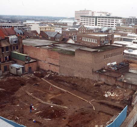 |
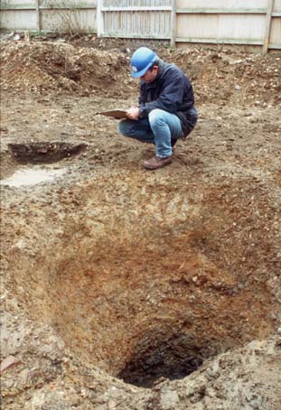
| A medieval well excavated behind 182-186 High Street | General view of Site looking West |
Area A
![]() This part of
the site was located to the rear of the shops fronting the High Street. The whole of Area
A had been subject to 19th and 20th century
disturbance but Phase I identified varying levels of preservation with the eastern half of
the site containing better preserved stratigraphy than the western half.
This part of
the site was located to the rear of the shops fronting the High Street. The whole of Area
A had been subject to 19th and 20th century
disturbance but Phase I identified varying levels of preservation with the eastern half of
the site containing better preserved stratigraphy than the western half.
![]() The first
part of Area A to be excavated, north of Atwells Yard, revealed a large rectangular timber
lined pit [141]. Pottery found in an upper fill has been identified as Post-medieval red
ware (1580-1900) and Post-Medieval yellow glazed redware (1480 -1650). Bones, including
cattle and sheep, cattle horncores and fish bones were found preserved in the lower fills
of this pit. This pit has, at present, been interpreted as a form of tanning pit.
The first
part of Area A to be excavated, north of Atwells Yard, revealed a large rectangular timber
lined pit [141]. Pottery found in an upper fill has been identified as Post-medieval red
ware (1580-1900) and Post-Medieval yellow glazed redware (1480 -1650). Bones, including
cattle and sheep, cattle horncores and fish bones were found preserved in the lower fills
of this pit. This pit has, at present, been interpreted as a form of tanning pit.
![]() To the west
of [141] was a small undated pit [484 ] which contained over a hundred cattle horncore
fragments. It is impossible to prove any connection between these two features other than
they both contain horncores.
To the west
of [141] was a small undated pit [484 ] which contained over a hundred cattle horncore
fragments. It is impossible to prove any connection between these two features other than
they both contain horncores.
![]() In area to
the west of 180/181 High Street two intercutting medieval linear boundary ditches were
recorded. These ditches [225] and [227] ran NE-SW across the site and contained pottery
and bone fragments. This later ditch [225] was found to be cut by a large oval pit [197]
which contained four fills. Although the upper and lower fills, which were both soft, mid
greenish grey clayey silt, contained pottery, bone and cbm fragments the quantity was
small. The density of the inclusions suggest that this pit may have been a quarry pit that
had been backfilled with domestic refuse. The pottery has been identified as Denham-type
ware.
In area to
the west of 180/181 High Street two intercutting medieval linear boundary ditches were
recorded. These ditches [225] and [227] ran NE-SW across the site and contained pottery
and bone fragments. This later ditch [225] was found to be cut by a large oval pit [197]
which contained four fills. Although the upper and lower fills, which were both soft, mid
greenish grey clayey silt, contained pottery, bone and cbm fragments the quantity was
small. The density of the inclusions suggest that this pit may have been a quarry pit that
had been backfilled with domestic refuse. The pottery has been identified as Denham-type
ware.
![]() A smaller
oval pit [221] was found adjacent to the ditch [225]. The fills of this pit were soft mid
brownish grey and mid greyish blue silty clay and contained occasional pottery fragments.
The pottery from both pits has been dated to the 11th to 14th centuries. Pit [221] contained a sherd of a London ware bowl.
A smaller
oval pit [221] was found adjacent to the ditch [225]. The fills of this pit were soft mid
brownish grey and mid greyish blue silty clay and contained occasional pottery fragments.
The pottery from both pits has been dated to the 11th to 14th centuries. Pit [221] contained a sherd of a London ware bowl.
![]() In the
southern corner of this part of Area A a series of intercutting pits were recorded. These
pits [153], [167], [169], and [171] contained similar fills. The fills were mid greyish
brown in colour and were composed of silty clay. These pits produced a substantial
assemblage of Denham ware, Coarse Border ware and South Hertfordshire greyware pottery
ranging in date from 1150 to 1500. This series of pits was half sectioned during Phase I
and then full excavated during Phase II allowing maximum finds retrieval.
In the
southern corner of this part of Area A a series of intercutting pits were recorded. These
pits [153], [167], [169], and [171] contained similar fills. The fills were mid greyish
brown in colour and were composed of silty clay. These pits produced a substantial
assemblage of Denham ware, Coarse Border ware and South Hertfordshire greyware pottery
ranging in date from 1150 to 1500. This series of pits was half sectioned during Phase I
and then full excavated during Phase II allowing maximum finds retrieval.
![]() In the south
west part of this area a Bronze Age gully was recorded during phase I. The rest of this
gully was excavated during the second phase and near to the limit of excavation a second
gully, on the same alignment as [165] was found to be terminating. This second gully [521]
was filled by a moderately compacted light yellowish brown silty clay that was identical
to the fill of [165]. This combined with only a short section of [521] being exposed made
finding the relationship between the two gullies impossible. However it was established
that the fill of [165] had been cut by several of stakeholes [187].
In the south
west part of this area a Bronze Age gully was recorded during phase I. The rest of this
gully was excavated during the second phase and near to the limit of excavation a second
gully, on the same alignment as [165] was found to be terminating. This second gully [521]
was filled by a moderately compacted light yellowish brown silty clay that was identical
to the fill of [165]. This combined with only a short section of [521] being exposed made
finding the relationship between the two gullies impossible. However it was established
that the fill of [165] had been cut by several of stakeholes [187].
![]() The other
features in this part of area A are post medieval in date and were probably associated
with the brewery and other industrial processes that took place on the site during the 19th century.
The other
features in this part of area A are post medieval in date and were probably associated
with the brewery and other industrial processes that took place on the site during the 19th century.
![]() The area to
the east of 180/181 High Street had been less truncated. On this area of the site several
flint wall foundations were recorded. These seem to corresponded with properties
illustrated on 19th century ordnance survey maps. Chalk floors were
also found to be associated with these flint foundations. Although these structures
produced very few finds the pottery found in the lower chalk surface was Early
Post-medieval red ware (1480 - 1600) and Red Border ware (1600 - 1800).
The area to
the east of 180/181 High Street had been less truncated. On this area of the site several
flint wall foundations were recorded. These seem to corresponded with properties
illustrated on 19th century ordnance survey maps. Chalk floors were
also found to be associated with these flint foundations. Although these structures
produced very few finds the pottery found in the lower chalk surface was Early
Post-medieval red ware (1480 - 1600) and Red Border ware (1600 - 1800).
![]() The chalk
floors had been constructed on top of levelling layers of gravel, also containing Early
Post-med red ware and Red Border ware, which in turn had been dumped over a greyish green
midden layer (404). This midden contained numerous fragments of Denham ware pottery but no
real quantity of bone fragments.
The chalk
floors had been constructed on top of levelling layers of gravel, also containing Early
Post-med red ware and Red Border ware, which in turn had been dumped over a greyish green
midden layer (404). This midden contained numerous fragments of Denham ware pottery but no
real quantity of bone fragments.
![]() This midden
layer was found to be sealing a number of features including a gully [312]. This gully was
truncated to the north by a large pit [272] and to the south by a linear feature [269].
The fill of [312] and the midden layer were virtually identical in colour, compaction and
composition and there was no definite break between the midden and the fill which would
indicate that this gully still functional up until the time when the midden was deposited
across the site.
This midden
layer was found to be sealing a number of features including a gully [312]. This gully was
truncated to the north by a large pit [272] and to the south by a linear feature [269].
The fill of [312] and the midden layer were virtually identical in colour, compaction and
composition and there was no definite break between the midden and the fill which would
indicate that this gully still functional up until the time when the midden was deposited
across the site.
![]() The large
elongated pit [272] to the north of [312] was originally thought to be a gully during
Phase I was also sealed by the midden layer. Phase II of the excavation revealed it’s
true extent. This pit which was 1m deep and 1.5m in width filled by a stiff dark brown
silty clay was truncated by another large elongated pit to the north. This second pit
[435] contained four silty clay fills which contained bone, cbm and pottery fragments. The
pottery has been dated to 1480 - 1600 and included sherds of an imported Raeren drinking
jug.
The large
elongated pit [272] to the north of [312] was originally thought to be a gully during
Phase I was also sealed by the midden layer. Phase II of the excavation revealed it’s
true extent. This pit which was 1m deep and 1.5m in width filled by a stiff dark brown
silty clay was truncated by another large elongated pit to the north. This second pit
[435] contained four silty clay fills which contained bone, cbm and pottery fragments. The
pottery has been dated to 1480 - 1600 and included sherds of an imported Raeren drinking
jug.
![]() It was found
that this pit was truncating a shallow linear ditch [478] to the north.
It was found
that this pit was truncating a shallow linear ditch [478] to the north.
![]() This ditch
which extended beyond the limit of excavation to the north was found to be a re-cut of
ditch [402]. Ditch [402] had a ‘U’ shaped profile and measured 0.6m in depth and
at least 0.8m in width and was filled by a moderate to firmly compacted light grey brown
clayey silt. A number of pottery fragments, some of which were decorated, were found at
the bottom of this fill. The majority of pottery was Denham ware but also present were
sherds of London type, Coarse London type and Calcareous London type wares.
This ditch
which extended beyond the limit of excavation to the north was found to be a re-cut of
ditch [402]. Ditch [402] had a ‘U’ shaped profile and measured 0.6m in depth and
at least 0.8m in width and was filled by a moderate to firmly compacted light grey brown
clayey silt. A number of pottery fragments, some of which were decorated, were found at
the bottom of this fill. The majority of pottery was Denham ware but also present were
sherds of London type, Coarse London type and Calcareous London type wares.
![]() This ditch
was not found on the southern side of [435] and it appears the terminus has been
truncated.
This ditch
was not found on the southern side of [435] and it appears the terminus has been
truncated.
![]() Boundary
ditch cut [269] was located on the southern side of the site close to the limit of
excavation. It was aligned east-west and ran for at least 18m across this area. The ditch
was found to be truncated at the western end by post medieval activity and by a modern
drainage on the northern side. The eastern end of the ditch began to curve towards the
north but it was not, however, recorded in the trench in Atwells Yard. This ditch
contained pottery dated to 12th century. This ditch had truncated gully [312] and may have
originally truncated [308].
Boundary
ditch cut [269] was located on the southern side of the site close to the limit of
excavation. It was aligned east-west and ran for at least 18m across this area. The ditch
was found to be truncated at the western end by post medieval activity and by a modern
drainage on the northern side. The eastern end of the ditch began to curve towards the
north but it was not, however, recorded in the trench in Atwells Yard. This ditch
contained pottery dated to 12th century. This ditch had truncated gully [312] and may have
originally truncated [308].
![]() This linear
feature, [308], which was 5.7m in length was truncated to the south by the modern drainage
cut and to he north by pit cut [272]. It appears to be a boundary division running
parallel to the High Street.
This linear
feature, [308], which was 5.7m in length was truncated to the south by the modern drainage
cut and to he north by pit cut [272]. It appears to be a boundary division running
parallel to the High Street.
![]() On the
western edge of the site, also aligned parallel to the High Street was a gully [332]. This
gully contained a dark greyish green cess like fill (331) which may have be the same
deposit as the midden layer. Pottery from this fill has been found to be between 1150 and
1300 in date. This gully continued to the north, on the other side of 19th century
building foundations, where it was recorded as [369].
On the
western edge of the site, also aligned parallel to the High Street was a gully [332]. This
gully contained a dark greyish green cess like fill (331) which may have be the same
deposit as the midden layer. Pottery from this fill has been found to be between 1150 and
1300 in date. This gully continued to the north, on the other side of 19th century
building foundations, where it was recorded as [369].
![]() Against the
limit of excavation in this corner of the site a second gully [328] was recorded. It was
truncated by [332] and further to the east it was truncated by [401]. This gully ran
almost parallel to [269] and is thought to be an earlier boundary division.
Against the
limit of excavation in this corner of the site a second gully [328] was recorded. It was
truncated by [332] and further to the east it was truncated by [401]. This gully ran
almost parallel to [269] and is thought to be an earlier boundary division.
![]() In the south
eastern corner of this part of the site the terminus for another ditch [258] was
excavated. Originally thought to be a pit, further excavation of this feature revealed it
to be a ditch running beyond the limit of excavation. No relationship was found between
[258] and [269] as they were separated by the modern drainage cut. It may be a latter
addition to the boundary ditch [269] but this can not be proven. Pottery fragments from
the fills of [258] have dated the feature to 12th and 13th centuries. The majority of the
sherds recovered are Denham ware with occasional sherds of London ware. The environmental
sample taken from the primary fill of [258] revealed the presence of small rodents bones.
In the south
eastern corner of this part of the site the terminus for another ditch [258] was
excavated. Originally thought to be a pit, further excavation of this feature revealed it
to be a ditch running beyond the limit of excavation. No relationship was found between
[258] and [269] as they were separated by the modern drainage cut. It may be a latter
addition to the boundary ditch [269] but this can not be proven. Pottery fragments from
the fills of [258] have dated the feature to 12th and 13th centuries. The majority of the
sherds recovered are Denham ware with occasional sherds of London ware. The environmental
sample taken from the primary fill of [258] revealed the presence of small rodents bones.
![]() To the north
of [258] a series of small pits were recorded. Again these pits have been dated to 1150 -
1300. One of the pits, [382], had been cut into a waterline gravelly fill. When this fill
was excavated and recorded Late Bronze Age/ Early Iron Age pottery fragments were found.
Excavation showed this gravel deposit to be filling a natural channel.
To the north
of [258] a series of small pits were recorded. Again these pits have been dated to 1150 -
1300. One of the pits, [382], had been cut into a waterline gravelly fill. When this fill
was excavated and recorded Late Bronze Age/ Early Iron Age pottery fragments were found.
Excavation showed this gravel deposit to be filling a natural channel.
![]() After the
removal the midden layer an oval shaped burnt area with a rectangular cut at either end
was recorded. Charcoal was found to be filling a shallow ovoid ring shaped cut [512] with
a central slot that was located in the centre of the larger area of burning. The
rectangular cuts contained charcoal and pottery fragments. The area of scorching was more
intense nearer the rectangular cuts. These may be the stoke pits of a kiln. The oval
burning (506) appears to be the base of a double flue updraught kiln typical of the type
in use during the 13th century.
After the
removal the midden layer an oval shaped burnt area with a rectangular cut at either end
was recorded. Charcoal was found to be filling a shallow ovoid ring shaped cut [512] with
a central slot that was located in the centre of the larger area of burning. The
rectangular cuts contained charcoal and pottery fragments. The area of scorching was more
intense nearer the rectangular cuts. These may be the stoke pits of a kiln. The oval
burning (506) appears to be the base of a double flue updraught kiln typical of the type
in use during the 13th century.
![]() The kiln
walls and internal features had been dismantled prior to the area being covered by the
midden layer. The central slot which would have held the support for the internal kiln
furniture was found to be full of charcoal similar to that found in the stoke pits which
appears to be deliberate backfilling of the slot.
The kiln
walls and internal features had been dismantled prior to the area being covered by the
midden layer. The central slot which would have held the support for the internal kiln
furniture was found to be full of charcoal similar to that found in the stoke pits which
appears to be deliberate backfilling of the slot.
![]() The pottery
fragments contained in the midden may have spread across the site from the kiln area.
The pottery
fragments contained in the midden may have spread across the site from the kiln area.
![]() A little way
to the south west of the kiln a round pit [300] which was 0.75m in diameter and 0.7m in
depth was recorded. This pit contained frequent sherds of Denham ware and charcoal
fragments and may be associated with the kiln.
A little way
to the south west of the kiln a round pit [300] which was 0.75m in diameter and 0.7m in
depth was recorded. This pit contained frequent sherds of Denham ware and charcoal
fragments and may be associated with the kiln.
![]() Also sealed
by the midden layer was a well [493]. This well, which was fully excavated and found to be
over 1.7m in depth, contained organic material such as charcoal and decayed wood fragments
in the lower fills although there was no evidence for a wood lining. The fills from the
well contained fragments of Denham ware as well as London Coarse ware and Kingston-type
ware (1230-1400)
Also sealed
by the midden layer was a well [493]. This well, which was fully excavated and found to be
over 1.7m in depth, contained organic material such as charcoal and decayed wood fragments
in the lower fills although there was no evidence for a wood lining. The fills from the
well contained fragments of Denham ware as well as London Coarse ware and Kingston-type
ware (1230-1400)
![]() Other
features from this area of the site include a line of Post medieval post holes [457],
[459], [461], [463], [465], [467], [469] and [471] found running east-west across the
site. These postholes may relate to boundary divisions which and may be associated with
the chalk floored building to the east.
Other
features from this area of the site include a line of Post medieval post holes [457],
[459], [461], [463], [465], [467], [469] and [471] found running east-west across the
site. These postholes may relate to boundary divisions which and may be associated with
the chalk floored building to the east.
![]() A number of
undated, circular post holes on the western side of the site between the limit of
excavation and gully [331] where also recorded.
A number of
undated, circular post holes on the western side of the site between the limit of
excavation and gully [331] where also recorded.
![]() A large
shallow rectangular pit containing Denham ware, Kingston ware and London ware was also
recorded near the limit of excavation to the north. Also on the northern edge of the
trench a circular pit [415] was recorded. This pit, the fill from which is (414),
contained charcoal, bone and pottery fragments that have been dated to 1350-1400 .
A large
shallow rectangular pit containing Denham ware, Kingston ware and London ware was also
recorded near the limit of excavation to the north. Also on the northern edge of the
trench a circular pit [415] was recorded. This pit, the fill from which is (414),
contained charcoal, bone and pottery fragments that have been dated to 1350-1400 .
![]() It was
revealed after the removal of features that most had been cut through a gravel surface.
This surface was a man made layer of compacted gravel that was used to consolidate the
ground, which when wet becomes very sticky. Although no dating was recovered from the
gravel it predates features containing 12th and 13th
century pottery and appears to have been laid down shortly after the boundary ditches had
been dug and the area occupied.
It was
revealed after the removal of features that most had been cut through a gravel surface.
This surface was a man made layer of compacted gravel that was used to consolidate the
ground, which when wet becomes very sticky. Although no dating was recovered from the
gravel it predates features containing 12th and 13th
century pottery and appears to have been laid down shortly after the boundary ditches had
been dug and the area occupied.
![]() This was the
largest area of the site in which nine trenches were excavated in total.
This was the
largest area of the site in which nine trenches were excavated in total.
![]() The
prehistoric activity on the site is indicative of a Bronze Age field system. A linear
gully which appears to be the remnants of a field enclosure was excavated in trench 4.
Evidence for this type of field system, which covered much of the prehistoric landscape in
West London, has been found elsewhere in Uxbridge although it is not possible to link this
feature with those found at 15 - 17, High Street in 1984.
The
prehistoric activity on the site is indicative of a Bronze Age field system. A linear
gully which appears to be the remnants of a field enclosure was excavated in trench 4.
Evidence for this type of field system, which covered much of the prehistoric landscape in
West London, has been found elsewhere in Uxbridge although it is not possible to link this
feature with those found at 15 - 17, High Street in 1984.
![]() No evidence
of medieval activity in this area was found apart from one sherd of Medieval Denham ware
pottery found within a layer of Post-medieval dumping. The majority of the features were
post medieval in date and this would correspond to this part of Uxbridge being open land
until the 18th and 19th centuries.
No evidence
of medieval activity in this area was found apart from one sherd of Medieval Denham ware
pottery found within a layer of Post-medieval dumping. The majority of the features were
post medieval in date and this would correspond to this part of Uxbridge being open land
until the 18th and 19th centuries.
![]() A number of
substantial houses, including The Lawns and The Shrubbery, were constructed in this area
during the early 19th century and features found in Area D, such as
the wells and other domestic features, may be associated with these buildings.
A number of
substantial houses, including The Lawns and The Shrubbery, were constructed in this area
during the early 19th century and features found in Area D, such as
the wells and other domestic features, may be associated with these buildings.
![]() The trench
closest to the listed building contained a deep wide feature [87] whose true extent is
unknown as it extended beyond the limits of the trench. The fills of this large cut
contained a high organic content. The lowest fill produced a range of finds including
fragments of Chinese and English porcelain, salt glazed stoneware tin glazed wares and
metropolitan red ware. The pottery ranges in date from 17th to the
19th century. Whet stones, ninety-six lead weights and three
articulated horse bones were also found in this feature. The feature itself may be a ditch
or a pond and may be associated with The Lawns that stands a few metres away. This feature
is not identified on mid 19th century maps of the area and it is
probable that the pond or ditch had silted up or had been backfilled by this time
The trench
closest to the listed building contained a deep wide feature [87] whose true extent is
unknown as it extended beyond the limits of the trench. The fills of this large cut
contained a high organic content. The lowest fill produced a range of finds including
fragments of Chinese and English porcelain, salt glazed stoneware tin glazed wares and
metropolitan red ware. The pottery ranges in date from 17th to the
19th century. Whet stones, ninety-six lead weights and three
articulated horse bones were also found in this feature. The feature itself may be a ditch
or a pond and may be associated with The Lawns that stands a few metres away. This feature
is not identified on mid 19th century maps of the area and it is
probable that the pond or ditch had silted up or had been backfilled by this time
![]() The results
from the excavations in Area A and D have begun to answer a number of questions.
The results
from the excavations in Area A and D have begun to answer a number of questions.
![]() One of the
first questions posed before the excavation took place was how and when was the town laid
out and was the development of the town in response to the granting of the market charter.
One of the
first questions posed before the excavation took place was how and when was the town laid
out and was the development of the town in response to the granting of the market charter.
![]() Area A, to
the rear of the High Street, produced evidence that is typical of a range of Medieval
activities taking place in the rear of properties fronting onto the High Street.
Area A, to
the rear of the High Street, produced evidence that is typical of a range of Medieval
activities taking place in the rear of properties fronting onto the High Street.
![]() In the
course of the excavation in this area it has been possible to identify three separate
burgage plots to the east of 180-181, High Street but no relationship was found between
these ditches and those recorded to the west of 180-181, High Street.
In the
course of the excavation in this area it has been possible to identify three separate
burgage plots to the east of 180-181, High Street but no relationship was found between
these ditches and those recorded to the west of 180-181, High Street.
![]() The way in
which the burgage plots had been laid out points to the town expanding from the west in a
easterly direction with the plot adjacent to George Street being the last plot to be
occupied. All the plots were laid out during the 12th and 13th century and this increase in activity and expansion of the town
coincides with the granting of the market charter during the 1180’s.
The way in
which the burgage plots had been laid out points to the town expanding from the west in a
easterly direction with the plot adjacent to George Street being the last plot to be
occupied. All the plots were laid out during the 12th and 13th century and this increase in activity and expansion of the town
coincides with the granting of the market charter during the 1180’s.
![]() Although the
plots remained, the level of activity decreased during the 14th
century and no significant activity has been recorded in this area until the 18th and 19th century. This may be as a result of the
area being terraced and early Post-medieval material having been destroyed by later
activity, although the lack of post-medieval intrusive features suggests that this is not
the case.
Although the
plots remained, the level of activity decreased during the 14th
century and no significant activity has been recorded in this area until the 18th and 19th century. This may be as a result of the
area being terraced and early Post-medieval material having been destroyed by later
activity, although the lack of post-medieval intrusive features suggests that this is not
the case.
![]() The
boundaries had changed little between the 13th century and the 19th century when Trumpers map of Uxbridge was drawn. The boundaries defined
by the burgage plot gullies were still in use 600 years later.
The
boundaries had changed little between the 13th century and the 19th century when Trumpers map of Uxbridge was drawn. The boundaries defined
by the burgage plot gullies were still in use 600 years later.
![]() The decline
in activity at the end of 13th century is indicative of lack of
vigour in the development of the town and possible contraction back to a nucleus around
the market place and the church. This type of contraction was not uncommon during this
period as towns had to cope with the declining level of population in the 14th century due
to economic factors and the Black Death.
The decline
in activity at the end of 13th century is indicative of lack of
vigour in the development of the town and possible contraction back to a nucleus around
the market place and the church. This type of contraction was not uncommon during this
period as towns had to cope with the declining level of population in the 14th century due
to economic factors and the Black Death.
![]() This part of
the town is close to the town boundary and is likely to have been abandoned as the town
declined. The town recovered but this area of the town was not intensively utilised again
until the 18th century. We can see from an 18th
century drawing, Panorama of Uxbridge, that the town had expanded again by this time with
all the available High Street frontage being occupied.
This part of
the town is close to the town boundary and is likely to have been abandoned as the town
declined. The town recovered but this area of the town was not intensively utilised again
until the 18th century. We can see from an 18th
century drawing, Panorama of Uxbridge, that the town had expanded again by this time with
all the available High Street frontage being occupied.
![]() The major
change in the Uxbridge occurs during the 19th century with the
arrival of the railways and other industrial developments with the town rapidly expanding.
The major
change in the Uxbridge occurs during the 19th century with the
arrival of the railways and other industrial developments with the town rapidly expanding.
![]() The
identification of differing usage between the plots and assessing the towns function was
also a consideration at the beginning of the excavation. The central plot may contain the
base of a 13th century updraught kiln. The burnt area below the kiln
had been covered by a midden layer which would suggest that the kiln had been dismantled
at some point possibly during the 14th century. The depressions left
by the removal of the internal fittings had been filled by a charcoal spread which in turn
had been sealed by the midden layer.
The
identification of differing usage between the plots and assessing the towns function was
also a consideration at the beginning of the excavation. The central plot may contain the
base of a 13th century updraught kiln. The burnt area below the kiln
had been covered by a midden layer which would suggest that the kiln had been dismantled
at some point possibly during the 14th century. The depressions left
by the removal of the internal fittings had been filled by a charcoal spread which in turn
had been sealed by the midden layer.
![]() This style
of kiln mainly occurs in southern England with slight regional variations in their design.
No other kiln has been found in Uxbridge. The nearest known site of pottery manufacture
was to the north at Denham.
This style
of kiln mainly occurs in southern England with slight regional variations in their design.
No other kiln has been found in Uxbridge. The nearest known site of pottery manufacture
was to the north at Denham.
![]() Denham type
wares, which are coarse domestic wares, are the dominant fabric type from this site and
some sherds show evidence of decoration including combing, applied strips and slashed and
pieced handles. Denham ware is a generic term used to describe the coarseware tradition of
the South Midlands greywares of this period. Similar types of pottery have been found at
Fulmer as well as the Denham kiln sites.
Denham type
wares, which are coarse domestic wares, are the dominant fabric type from this site and
some sherds show evidence of decoration including combing, applied strips and slashed and
pieced handles. Denham ware is a generic term used to describe the coarseware tradition of
the South Midlands greywares of this period. Similar types of pottery have been found at
Fulmer as well as the Denham kiln sites.
![]() Similar
shaped double flue updraught kilns have been found in Cheam. The first was excavated in
1924 and the other during the 1960’s
Similar
shaped double flue updraught kilns have been found in Cheam. The first was excavated in
1924 and the other during the 1960’s
![]() No obvious
wasters were found from the site. Only one misshapen sherd was recorded and this was found
in the midden layer (404). This would tend to suggest that this feature was not used for
pottery production. However over 97,000 small pot sherds were recovered from four kilns
excavated at Rush Green in Denham in 1988 and here too there was a distinct lack of
wasters. The only sherds that could definitely be describe as wasters from that site were
one or two distorted fragments and one glazed handle from the top soil.
No obvious
wasters were found from the site. Only one misshapen sherd was recorded and this was found
in the midden layer (404). This would tend to suggest that this feature was not used for
pottery production. However over 97,000 small pot sherds were recovered from four kilns
excavated at Rush Green in Denham in 1988 and here too there was a distinct lack of
wasters. The only sherds that could definitely be describe as wasters from that site were
one or two distorted fragments and one glazed handle from the top soil.
![]() In
conclusion we have found that Area A and Area D have shown that the medieval market town
of Uxbridge was defined by the burgage ditch. All medieval activity has been found in side
the area enclosed by this town ditch.
In
conclusion we have found that Area A and Area D have shown that the medieval market town
of Uxbridge was defined by the burgage ditch. All medieval activity has been found in side
the area enclosed by this town ditch.
![]() Summary of the Excavations in
Areas B, CI and CII
Summary of the Excavations in
Areas B, CI and CII
This was the final phase of a two year programme of evaluation and excavation on the site of the proposed shopping centre development in Uxbridge High Street. At the time of writing the finds and environmental samples are being processed and subsequently only very basic dating information is available.
The results from previous excavated areas (A and D) of the site suggested that the Medieval town of Uxbridge was confined to an area within the town boundary as depicted on Trumper’s map of 1825. This map shows the town boundary running down George Street then crossing the High Street obliquely and continuing down Vine Street.
The abundance of Medieval activity from areas to the west of George Street and the lack of material from the east of George Street that had been recorded over the past few months supported the idea that the town boundary of the 19th century was closely respecting the alignment of the burgage ditch of the 12th and 13th centuries.
![]() Area
B
Area
B
The town boundary was thought to be defined by a ditch on the alignment of George Street. Excavations carried out in Area B produced no evidence of any form of boundary marker, however the area had been severely truncated by numerous services in the street and substantial building foundations on the eastern side of George Street which may have obliterated any evidence of a burgage ditch.
![]() Area
CII
Area
CII
![]() This final
phase of excavation, adjacent to the High Street and to the east of George Street, has
shown a remarkable similar pattern of occupation and land use to that recorded to the west
of George Street. The area was divided up by burgage plot gullies and gravel surfaces laid
down to consolidate the ground with pits and postholes being cut through this gravel.
This final
phase of excavation, adjacent to the High Street and to the east of George Street, has
shown a remarkable similar pattern of occupation and land use to that recorded to the west
of George Street. The area was divided up by burgage plot gullies and gravel surfaces laid
down to consolidate the ground with pits and postholes being cut through this gravel.
![]() The first
phase of activity on this part of the site dates from the 12th century. Three properties
have been identified. These properties were separated by a series of burgage plot gullies,
[1152], [1157], [1135], running at right angles to the High Street on a roughly NE - SW
alignment. A series of three gullies ([1128], [1150] and [1101]) running parallel to the
High Street on a NW - SE axis were found in the central property and may have been used to
divide this property into areas of different land use. The environmental samples which are
being processed may contain material showing how these different areas of the property
were used ie industrial, agricultural, horticultural or domestic activity. Several
medieval pits were found to be truncating these gullies and this later activity had
destroyed the relationships between them so it is not certain which of the gullies was dug
first and so it is not yet clear in which direction the town was expanding at this point
in the High Street.
The first
phase of activity on this part of the site dates from the 12th century. Three properties
have been identified. These properties were separated by a series of burgage plot gullies,
[1152], [1157], [1135], running at right angles to the High Street on a roughly NE - SW
alignment. A series of three gullies ([1128], [1150] and [1101]) running parallel to the
High Street on a NW - SE axis were found in the central property and may have been used to
divide this property into areas of different land use. The environmental samples which are
being processed may contain material showing how these different areas of the property
were used ie industrial, agricultural, horticultural or domestic activity. Several
medieval pits were found to be truncating these gullies and this later activity had
destroyed the relationships between them so it is not certain which of the gullies was dug
first and so it is not yet clear in which direction the town was expanding at this point
in the High Street.
![]() After the
burgage gullies had been constructed gravel (1183) was laid down to form a hard surface.
This gravel was later truncated by medieval pits including [1001] and [1168] which had
been dug adjacent to property boundaries.
After the
burgage gullies had been constructed gravel (1183) was laid down to form a hard surface.
This gravel was later truncated by medieval pits including [1001] and [1168] which had
been dug adjacent to property boundaries.
![]() The gravel
yard surface in the central property had been truncated by two parallel lines of postholes
the finds from which are at present awaiting dating. The gravel had also being truncated
by post medieval activity including wall foundations and pits.
The gravel
yard surface in the central property had been truncated by two parallel lines of postholes
the finds from which are at present awaiting dating. The gravel had also being truncated
by post medieval activity including wall foundations and pits.
![]() The finds
assemblage was similar to that found in Area A, predominantly Denham ware was recovered
from the gullies and medieval pits which indicates that both areas of the town were
occupied at the same time with similar activity occurring on both sides of George Street.
As in Area A there was a distinct lack of animal bone. The animal bone that was recovered
was well preserved so other factors will have to be looked at to explain the absence of
bone, a material so common on most medieval urban sites.
The finds
assemblage was similar to that found in Area A, predominantly Denham ware was recovered
from the gullies and medieval pits which indicates that both areas of the town were
occupied at the same time with similar activity occurring on both sides of George Street.
As in Area A there was a distinct lack of animal bone. The animal bone that was recovered
was well preserved so other factors will have to be looked at to explain the absence of
bone, a material so common on most medieval urban sites.
![]() No evidence
for activity immediately adjacent to the High Street was recorded except for a shallow
road side ditch which was also Medieval in date. This lack of evidence is probably due to
the area being extensively truncated by 19th and 20th century buildings.
No evidence
for activity immediately adjacent to the High Street was recorded except for a shallow
road side ditch which was also Medieval in date. This lack of evidence is probably due to
the area being extensively truncated by 19th and 20th century buildings.
![]() CI
CI
![]() This area
was the located on the very eastern part of the site, in the vicinity of the Medieval
hamlet of Hillingdon End; only very ephemeral Medieval activity in the form of isolated
shallow post holes, a boundary gully and residual pottery fragments were recorded but the
area which had been heavily truncated by 18th and 19th century buildings, yard surfaces
and pits.
This area
was the located on the very eastern part of the site, in the vicinity of the Medieval
hamlet of Hillingdon End; only very ephemeral Medieval activity in the form of isolated
shallow post holes, a boundary gully and residual pottery fragments were recorded but the
area which had been heavily truncated by 18th and 19th century buildings, yard surfaces
and pits.
![]() A chalk
floor and its associated gravel levelling layer was recorded and found to be similar to
the chalk floor that had been recorded in Area A which possibly dates to the 16th century
although it may be much later.
A chalk
floor and its associated gravel levelling layer was recorded and found to be similar to
the chalk floor that had been recorded in Area A which possibly dates to the 16th century
although it may be much later.
![]() The area
between CI and CII which was not originally included in the shopping centre scheme was
found to be heavily truncated by 20th century buildings with only two late medieval /
early post medieval wells surviving.
The area
between CI and CII which was not originally included in the shopping centre scheme was
found to be heavily truncated by 20th century buildings with only two late medieval /
early post medieval wells surviving.
![]() Conclusions Areas B, CI and CII
Conclusions Areas B, CI and CII
![]() A similar
pattern of occupation has been recorded in Area CII as was seen in Area A. Both areas of
the High Street were first occupied at the same time during the 12th and 13th centuries.
There follows a marked decline in the fortunes of the town with a distinct lack of
activity until the 18th century when Uxbridge seems to have become more prosperous.
A similar
pattern of occupation has been recorded in Area CII as was seen in Area A. Both areas of
the High Street were first occupied at the same time during the 12th and 13th centuries.
There follows a marked decline in the fortunes of the town with a distinct lack of
activity until the 18th century when Uxbridge seems to have become more prosperous.
![]() It was not
expected that the medieval occupation would extend to the east of George Street. This was
based on the assumption that the town boundary of the 18th and 19th centuries respected an
earlier medieval town boundary. It could be that the town boundary had shifted by the 19th
century or that the medieval town had expanded very rapidly beyond the burgage ditch by
the 13th century shortly after the granting of the market charter in about 1180. It may be
that in fact the town boundary had become not some much a physical limit but more a legal
demarcation of an area that was defined as the ‘town of Uxbridge’ with its
associated market.
It was not
expected that the medieval occupation would extend to the east of George Street. This was
based on the assumption that the town boundary of the 18th and 19th centuries respected an
earlier medieval town boundary. It could be that the town boundary had shifted by the 19th
century or that the medieval town had expanded very rapidly beyond the burgage ditch by
the 13th century shortly after the granting of the market charter in about 1180. It may be
that in fact the town boundary had become not some much a physical limit but more a legal
demarcation of an area that was defined as the ‘town of Uxbridge’ with its
associated market.
![]() At present
no evidence for specific activity such as industrial processes has been recorded from
either CI or CII however environmental samples taken from pit, ditch and posthole fills
may provide an indication as to the nature of land use in this part of the High Street. It
will be interesting to see how they compare and if there are marked similarities or
differences between the samples taken from Area A.
At present
no evidence for specific activity such as industrial processes has been recorded from
either CI or CII however environmental samples taken from pit, ditch and posthole fills
may provide an indication as to the nature of land use in this part of the High Street. It
will be interesting to see how they compare and if there are marked similarities or
differences between the samples taken from Area A.
![]() The residual
medieval finds from CII were recovered from a layer of subsoil but the pottery fragments
were very abraded and may be present as a result of domestic waste being used to manure
the fields that would have surrounded the town.
The residual
medieval finds from CII were recovered from a layer of subsoil but the pottery fragments
were very abraded and may be present as a result of domestic waste being used to manure
the fields that would have surrounded the town.
![]() The lack of
bone from the site as a whole is of interest especially as by 1300 Uxbridge had a weekly
market and two annual fairs solely for the sale of livestock. It would be strange that the
documented trade in animals did not support associated industries such as butchery and
those using animal by-products.
The lack of
bone from the site as a whole is of interest especially as by 1300 Uxbridge had a weekly
market and two annual fairs solely for the sale of livestock. It would be strange that the
documented trade in animals did not support associated industries such as butchery and
those using animal by-products.
![]() It can be
suggested that the sharp down turn in activity across the site during the 14th century was
due to social and economic problems of the early and mid part of the century which
included severe famines and the black death. English society saw many changes as a result
of plague which killed around 1/3 of the population. Reductions in population lead to
pressure on trade and it is likely that the remaining population would take up better
opportunities congregating in larger towns and cities with smaller towns such as Uxbridge
suffering as a result. Uxbridge seems to have been slow to recover, this may be a result
of the proximity of London and the opportunities it offered.
It can be
suggested that the sharp down turn in activity across the site during the 14th century was
due to social and economic problems of the early and mid part of the century which
included severe famines and the black death. English society saw many changes as a result
of plague which killed around 1/3 of the population. Reductions in population lead to
pressure on trade and it is likely that the remaining population would take up better
opportunities congregating in larger towns and cities with smaller towns such as Uxbridge
suffering as a result. Uxbridge seems to have been slow to recover, this may be a result
of the proximity of London and the opportunities it offered.
![]() Areas CI and
CII produced even less late medieval activity than Area A which would suggest that the
excavated area and the town were focussed toward the market place and the church with the
outlying areas being most seriously affected by the very long recession in the town’s
fortunes.
Areas CI and
CII produced even less late medieval activity than Area A which would suggest that the
excavated area and the town were focussed toward the market place and the church with the
outlying areas being most seriously affected by the very long recession in the town’s
fortunes.
The excavations were set up by the Borough Council and were arranged and paid for by Royal and Sun Alliance and Capital Shopping Centres (CSC). The excavation was carried out by MoLAS (Museum of London Archaeology Service).
If you came to this page directly without coming via Hillingdon On-line please click here
Hillingdon On-line is best viewed using one of the following browsers.
Follow these links to get download instructions to lay hands on the software for free!